Bad news from forecasters with the U.S. National Weather Service Austin-San Antonio in New Braunfels today.
No significant improvement in south-central Texas’ drought status is likely over the next one to two months, the weather service said in today’s South Central Texas Drought Briefing.
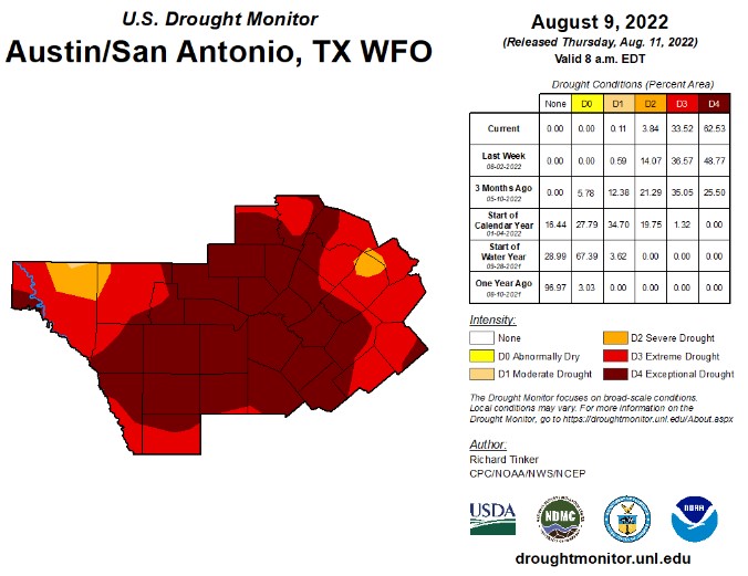
Extreme to exceptional drought conditions now cover more than 96% of the regional office’s 33-county region.
Only spotty, very minor improvements are possible from rains this week. Long-term outlooks suggest drought impacts will continue this fall.
Impacts will continue to worsen for water resources, agriculture and fire danger.
“A continued lack of rain over the next month or so could mean a very active fire fall season is in store,” NWS said.
Outlooks for fall into winter are grim as well, showing a likelihood of warmer-than-normal conditions as La Nina conditions are likely to persist through early 2023.
NWS said the last 30 days in the Canyon Lake and New Braunfels areas have been dry to very dry. Some locations in the NWS region have seen no rain at all for over five weeks.
Most of south-central Texas has received less than half the normal rainfall over the past 90 days, with some areas less than 25%.
According to the U.S. Geological Survey (USGS) information on hydrologic impacts, seven-day streamflows remain below- to much-below normal across the majority of basins in south-central Texas. Most areas east of U.S. Highway 281 have streamflows between the 10th and 25th percentiles.
The good news is that September/October are typically the second-wettest months of the year for the area, so minor relief could be on the horizon, NWS said.
To see today’s South Central Texas Drought Briefing click here.